lunes, 28 de septiembre de 2015

Homework # 3  Block1

1.- Go to your dropbox. Ms. Nitza's class, homework folder.
2.- Get the table from the picture that says homework #3 
3.- Paste it into Good Notes.  
4.- Answer your activity of locating the cities.
5.- After answering, locate the cities in your map, it doesn't matter it's not exact point, but I want you to know where they are.
6.- Here are the links where you can have help locating the points of latitude and longitude: 

http://www.findlatitudeandlongitude.com/
http://www.movable-type.co.uk/scripts/latlong.html
http://itouchmap.com/latlong.htm

These are my suggestions but if you find another page that can help you please use it! =)
ALL ARE IMPORTANT CITIES FROM THE WORLD


domingo, 27 de septiembre de 2015

How do I use Maps and Globes?

Hemispheres 
      To locate places on the earth, geographers use a system of imaginary lines that crisscross the globe. One of these lines, the Equator, circles the middle of the earth like a belt. It divides the earth into "half spheres", or hemispheres. Everything north of the Equator is in Northern Hemisphere, everything south of the Equator is in the Southern Hemisphere. 
        Another imaginary line runs from north to south, called the Prime Meridian  It helps divide the earth into half spheres in the other direction. The Prime Meridian will divide earth also in half, everything east of the Prime meridian for 180 degrees is in the Eastern Hemisphere, everything west of the Prime Meridian for 180 degrees is the Western Hemisphere.


Understanding Latitude and Longitude 

Lines on globes and maps provide information that can help you easily locate places on earth. These lines -called latitude and longitude- cross one another, forming a pattern called a grid system.


       Latitude   Lines of latitude, or parallels, circle the earth parallel to the Equator and measure the distance north or south of the equator in degrees. The equator is at 0 degrees latitude, while the North Pole lies at latitude 90˚ (north) 


Longitude   Lines of longitude, or meridians, circle the earth from Pole to Pole. These lines measure distances east to west of the starting line, which is at 0 degrees longitude called the Prime Meridian. The Prime Meridian runs through the Royal Observatory in Greenwich, England. 


Absolute location    The grid system formed by lines of latitude and longitude makes it possible to find the absolute location of a place. Only one place can be found at the point where a specific line of latitude crosses a specific line of longitude. By using degrees (˚) and minutes (') (points between degrees), people can pinpoint the precise spot where one line of latitude crosses one line of longitude-an absolute location. 

Visit the following address so you can watch a video about all this information.
http://youtu.be/swKBi6hHHMA

Resources: 
Geography The World and Its People, Boehm, Armstrong, Lobrecht, Hunkins, Reinhartz. Mc Graw Hill. 2007. 

http://www.youtube.com/watch?v=swKBi6hHHMA

http://www.google.com/imgres?num=10&um=1&hl=en&biw=1366&bih=600&tbm=isch&tbnid=hrsAs1bSC_PaKM:&imgrefurl=http://www.wbwells.com/2012/surveying/longitude/&docid=_QkgNPeWfEFX6M&imgurl=http://www.wbwells.com/wp-content/uploads/2012/04/global_longitude.jpg&w=502&h=442&ei=OflkUJnvEIHW2AXxlYG4CQ&zoom=1&iact=rc&dur=2&sig=117461693911554293376&sqi=2&page=1&tbnh=110&tbnw=132&start=0&ndsp=24&ved=1t:429,r:9,s:0,i:126&tx=347&ty=393


domingo, 20 de septiembre de 2015

2.1 Geographic Space Representation

How to represent the geographic space... 


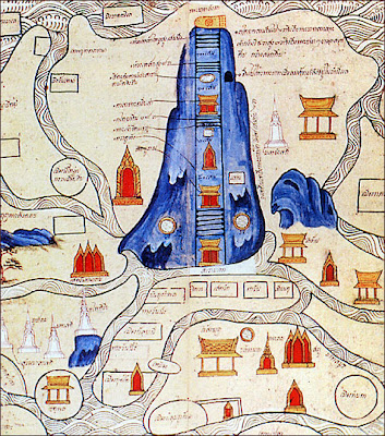
Since the past, human beings have had the necessity of searching or investigating how is the place where we live. The first humans that live in the world made their representations by doing some drawings where they painted natural resources like mountains, rivers, oceans, caves or other common features that surrounded them. To have a better idea of their space, these men used to go to the highest pick and look to their surroundings so they can start doing their sketches; others, used to travel by the shores and in that way they could have the maps of the territory they lived in; they were also guided by the sun or the stars. 
Can you imagine having the maps from that time, do you think we could be able to understand them? 
Source:  http://www.ballantynethebrave.com/blog/topical/cartography/

Source: mappa.mundi.net


"What we all love about ancient maps is that they communicate more than mere spacial, geographic concepts. They are treasure troves of information and insights into past cultures, revealing notions of sovereignty, nationhood, national priorities and loyalties, the level of scientific advancement of the day, astronomical charts, religious beliefs, speculations of deep sea creatures, and the locations of important events. Modern maps are, thanks to scientific advancements, more accurate and precise, but sadly, they have lost a lot of their depth of meaning." (ballantynethenbrave.com blog)  


It was until XIX and XX century when technology advances allowed the improvement of maps because it make them close to reality.   
Today, we can use different things to get to know our geographic space, there are satellite images, aerial pictures, 3d maps, sketches, GPS, even a globe. 
Who make those maps? For what reason we need pictures from satellites? There are a lot of reasons why we need them; imagine your family wants to establish a business, let's say a restaurant, how they are going to search about the area where to put the restaurant? Using images from satellites we can search about location, if it's good or convenient. How do you think they can search people? YES! with maps! According to the interest is what you will use. 

Types of Representation... 

 *Sketch: The easiest way to represent geographic space, it's a simple drawing that works to locate a place and its route. 


*Map: It is the most conventional way to represent a humanized space, it needs to have very specific directions. 


*Globe: A sphere that has the most accurate representation, why? because is the same shape as our planet! 


*Satellite images: Is an image taken from space by a satellite, using this image we can know about process and natural phenomena that affect geographic psace. Nowadays we have Google Earth as well as Google Maps. 

*3d Images: They represent a part of the land, specifically landforms like mountains, hills, etc. With this tool we can get a more real idea about our geographic space. 

*Aerial photo: these photos are taken with special cameras that are placed in airplanes flying at certain height; these pictures are used to create maps. 


miércoles, 9 de septiembre de 2015

1.2 Geographic Space Analysis

Geographic Space Analysis Categories 
The analysis of the Geographic Space will let you understand and comprehend that we belong to a time and space, that we are related with the natural process that happen around us, that the world changes and affects our lives. 

1-Landscape
Natural Landscape 
A landscape is all what you can see with your eyes, it needs to have common features, could be natural, social, or made by human. 

2- Geographical Area 
Rural Area 

Urban Area

Geographical area, where life can be developed, relationship between nature and society. 

3- Region 
Regions

Mayan Region
A region is an area that shares certain features like climate, vegetation, land forms, even culture, like its shown in the picture, the Mayan region; can you recall another region from your country? 

4- Territory
Mexico's Territory
It is an area under a government, could be a whole country, a province, a city, but it includes everything, the soil, subsoil, territorial water, aerial space and of course its natural resources. 

5- Place 
Your school
A place can be a location, a neighborhood, where people create communication with each other, special bonds, either social, economic or cultural so they can be integrated to a group. 

Activity #5
Copy into your notes the activity is called GeographicSpaceCompareChart,you can find it in Activities folder; follow directions and add a title. 
Activity #6
Get into Dropbox and find the word search about this topic.